
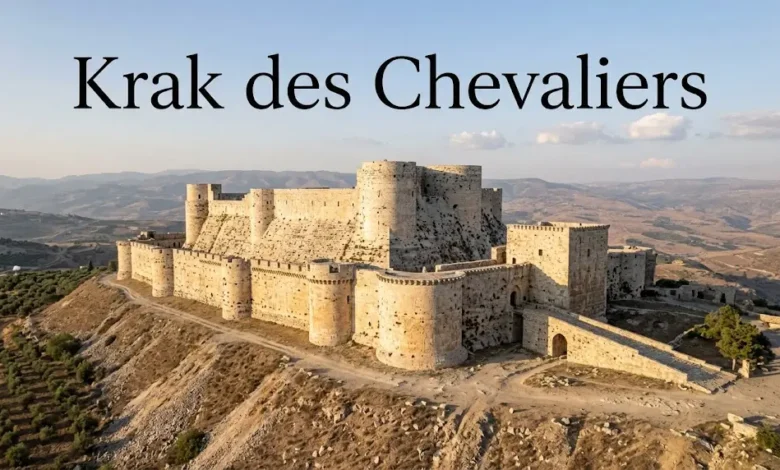
The walls above al-Hosn are not one castle. They’re a Kurdish garrison’s site, a Hospitaller fortress, a Mamluk repair, and a village that was emptied in 1933.
The wind on the south face hits the talus first, then your face. I was eleven, up from Homs on a school trip, and a teacher told us to put a hand on the stone before anybody talked. The limestone was warm on the surface and cold a knuckle deeper. That was my introduction to Krak des Chevaliers, and it beat the sentence most books still open with.
Krak des Chevaliers stands about forty kilometres west of Homs, on a spur at roughly 650 metres, above the village of al-Hosn in Homs Governorate. Hold onto that. The rest of the popular version — a French fairy-tale castle, “built in 1031,” staffed by two thousand knights, lost because of a forged letter — doesn’t survive the masonry, or the Arabic chronicles.
Archaeologist Abdul Hamid Raed Hindawi — Historical Reviewer
Dr. Abdul Rahman Al-Shahbandar — History Professor & Researcher
- Krak des Chevaliers stands ~40 km west of Homs, at ~650 m elevation, above the village of al-Hosn.
- Its Arabic name is Hisn al-Akrad (“Fortress of the Kurds”); “Krak” derives from Frankish mishearing (Cratum → Le Crat → Crac).
- The inner ward dates to the Hospitaller build-out from the 1140s; the outer double wall is a 13th-century addition, not part of a single 1031 construction.
- Sultan Baybars captured the castle on 8 April 1271, after mining brought down the southwest tower on 29 March.
- 1031: Kurdish garrison noted by Ibn Shaddad (no surviving fabric).
- 1142: Raymond II of Tripoli grants the site to the Knights Hospitaller.
- 1271–1285: Mamluk reconstruction under Sultan Baybars and Sultan Qalawun.
- 2006 / 2013 / 2026: UNESCO inscription, Danger List listing, and latest conservation decision (48 COM 7A.17).
Why Is Krak des Chevaliers Also Called Hosn al-Akrad?
People in al-Hosn say Qal’at al-Hosn. The historical Arabic name is different. Ḥiṣn al-Akrād means the Fortress of the Kurds, and English usually writes it Hosn al-Akrad.
The Frankish documents started from that second word. They wrote Cratum, then Le Crat. Somewhere in the copying, Crat slid toward the Arabic karak, a fortress, and French settled on Crac des Chevaliers. English often prefers Krak. Same place. UNESCO’s list still uses the French spelling, Crac des Chevaliers, for the joint property it inscribed with Qal’at Salah El-Din.
None of these names is the name of the first settlement on the spur. The thirteenth-century historian Ibn Shaddad, writing long after the fact, says that in 1031 the Mirdasid emir Shibl al-Dawla Nasr planted a Kurdish garrison here and that the site was then called Ḥiṣn al-Safḥ. Ḥiṣn al-Akrād came with the garrison. It is a name for men posted on a ridge, not a foundation inscription for the walls you walk through now.
And this is where guidebooks go wrong. They treat 1031 as the birthday of the surviving castle. No trace of that first stronghold has been identified in the standing fabric. The date is a later chronicle notice. Useful. Not a construction date.
Where Is Krak des Chevaliers, and Why Did the Homs Gap Matter?
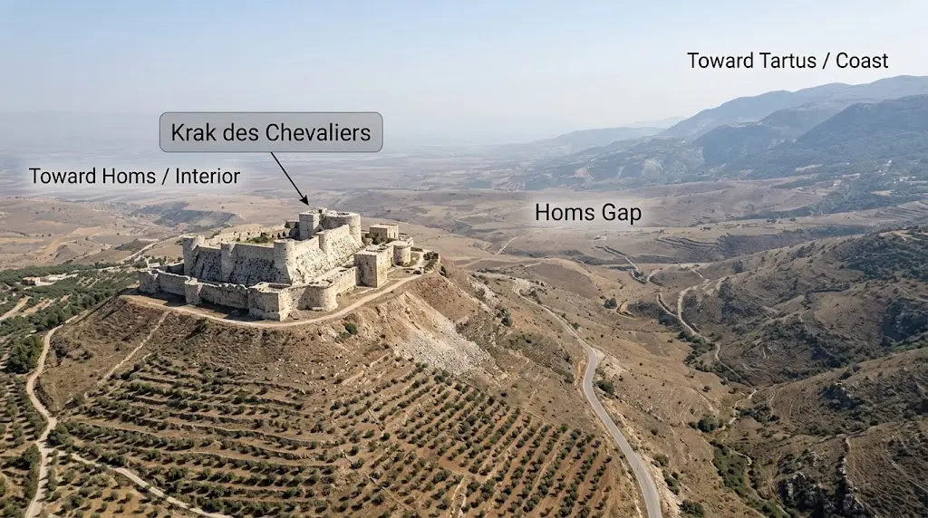
Leave Homs toward the west and the Orontes plain narrows into the Homs Gap, the low corridor between the coastal range and the interior. Tartus and Tripoli sit on the sea side. Homs sits inland. Whoever held the spur above al-Hosn had eyes on the road armies actually used.
That is the strategic fact. Not a view. A road.
The castle’s plan admits it. The spur isn’t a neat oval, so the enceinte isn’t a neat oval either. Square towers of the inner ward sit where the twelfth-century builders found rock. The later outer wall follows the slope instead of correcting it. From the southern glacis you look down onto terraces — olives, a few figs — and then the gap. Modern houses climb the eastern slopes toward the buffer. UNESCO has been complaining about those houses since the nomination. They’re still in the 2026 decision.
I don’t romanticize the gap. I’ve driven it in summer, windows down, the air off the limestone dry enough to catch in your throat, trucks using the same saddle that mule trains used. Geography here is a constraint on movement. The Hospitallers understood that. So did Baybars.
Read Also: Wildlife of Syria: Animals, Habitats and Biodiversity
When Was Krak des Chevaliers Built?
Not in one campaign. Not by one patron.
The sequence that the fabric and the documents will actually support runs like this. A Kurdish garrison is attested, through Ibn Shaddad, for 1031. In February 1099 a company under Raymond of Toulouse took the place briefly on the road south and then left it. The grant that matters is later. In 1142 Raymond II, count of Tripoli, handed the site to the Order of the Hospital of Saint John of Jerusalem — the Knights Hospitaller, not the Templars. Some discussions of the charter stretch the paperwork to 1144. The year people should remember is 1142. From then until 8 April 1271 the Hospital held it, inside the County of Tripoli, as the inland anchor of a line that also included the coastal castle of Margat.
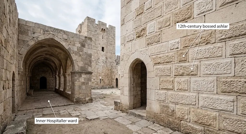
The first Hospitaller castle, built out from the 1140s and knocked about by earthquakes in 1157 and on 29 June 1170, is the inner enclosure. Square towers. A courtyard. Vaulted rooms against the curtains. Bossed ashlar, finely cut. Hugh Kennedy, in Crusader Castles (Cambridge University Press, 1994), treats that bossed work as the twelfth-century signature. The 1170 quake ruined the chapel. The chapel standing now — barrel-vaulted, three bays, about 21.5 metres long and 8.5 wide — replaced it.
Then the outer circuit. An earthquake in 1202 is the usual explanation for the rebuild, and it may be right. Or the outer wall belongs later, toward the middle of the thirteenth century, when counterweight artillery and professional miners had changed what an outer ward was for. I’ve watched that dating move. I won’t freeze it. What I will say is that the thirteenth-century work, not the 1031 garrison, produced the double wall visitors mean when they talk about Krak des Chevaliers architecture.
Nur al-Din came against it in 1163 and didn’t take it. Saladin came in the summer of 1188, after Hattin, looked at the new work, and didn’t take it either. Those two failures are the political context. They aren’t an excuse to retell the Crusades.
| Period | Builder / Authority | What Was Built or Changed | Status |
|---|---|---|---|
| 1031 | Mirdasid emir Shibl al-Dawla Nasr | Kurdish garrison established at Hisn al-Safh (no surviving fabric identified) | Documented, not visible |
| February 1099 | Raymond of Toulouse | Brief occupation during the march south; site then abandoned | Transient |
| 1142 (some sources: 1144) | Raymond II, Count of Tripoli / Knights Hospitaller | Grant of the site to the Hospital of Saint John of Jerusalem | Foundational grant |
| 1140s–1170 | Knights Hospitaller | First Hospitaller castle: inner enclosure, square towers, bossed ashlar masonry | Standing fabric |
| After 1170 earthquake | Knights Hospitaller | Rebuilding of the chapel (barrel-vaulted, three bays, ~21.5 x 8.5 m) | Standing fabric |
| Early–mid 13th century | Knights Hospitaller | Outer defensive circuit and sloping glacis added (date debated: c. 1202 earthquake or mid-century siege response) | Dating debated |
| 1271 and after | Sultan Baybars / Sultan Qalawun (1285) | Reconstruction of the southwest tower, southeast gate tower, eastern enceinte (1278), additional tower (1285) | Standing fabric |
How Did Sultan Baybars Capture Krak des Chevaliers?
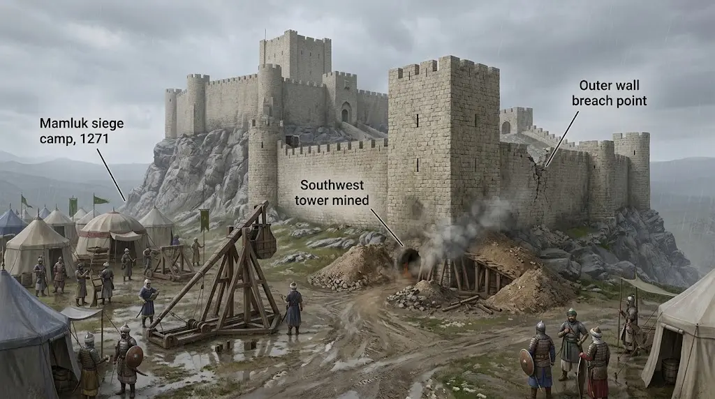
Baybars had already taken the smaller forts around the gap, including Chastel Blanc, before he brought a Mamluk army up to the spur. The Arabic narratives aren’t perfectly consistent about the first days. Hugh Kennedy’s reconstruction, at pages 148–150 of Crusader Castles, has the army at the castle on 3 March 1271, possibly after a blockade had already started. Ibn Shaddad — a contemporary, though he wasn’t standing on the wall — says an outer line fell within about two days. D. J. Cathcart King thought that line was probably the walled suburb below the entrance, not the castle proper. King argued this in Antiquity in 1949, volume 23, pages 83–92, and the pages that still matter are 88–92.
Rain stalled the machines. On 21 March the triangular outwork south of the castle was taken. On 29 March miners from Aleppo brought down the southwest tower. The breach opened the outer ward. Peasants who had packed into that ward were turned out to go back to their fields. Mountain mercenaries were imprisoned. Hospitallers who hadn’t made it into the upper castle were killed.
Then a pause. On 8 April 1271 the garrison asked for amān and got it. Safe conduct toward Tripoli. Not a massacre in the inner ward. If you’ve read an account in which the knights are slaughtered after the inner wall collapses, throw it out. The French Ministry of Culture’s site on the castle, which follows the Arabic sequence and the repairs, has the Hospitallers requesting amān on that April date. So does Kennedy.
Now the letter. Several modern retellings, and the Ministry’s own siege page, say Baybars sent a forged order — sometimes from the Hospitaller master, sometimes from the count of Tripoli — telling the garrison to yield. Maybe he did. Ibn Shaddad’s narrative tradition is where the story lives, and King already warned in 1949 that the Arabic accounts “are not perfectly clear.” A forged letter is also a very old way to explain a surrender that embarrasses the losing side.
I’ll say what I think. The letter is not the event. The mine under the southwest tower is the event. Once that tower was down and the outer ward was lost, no relief column was coming up the gap. Amān was the rational end. Centering the fall of this castle on a trick of correspondence is how popular history avoids reading the breach.
The damage matches that reading. The Ministry’s architectural account says the southern face took the bombardment badly enough to be refaced, and that the northern postern — the one surveyors call Nicolas Lorgne’s barbican — and the east gate were rebuilt after the siege. King and, later, Jean Mesqui have argued that the inner enceinte itself was not wrecked in 1271. Believe the refacing you can see. Don’t invent a second collapse for drama.
What Did Mamluk Builders Change After April 1271?
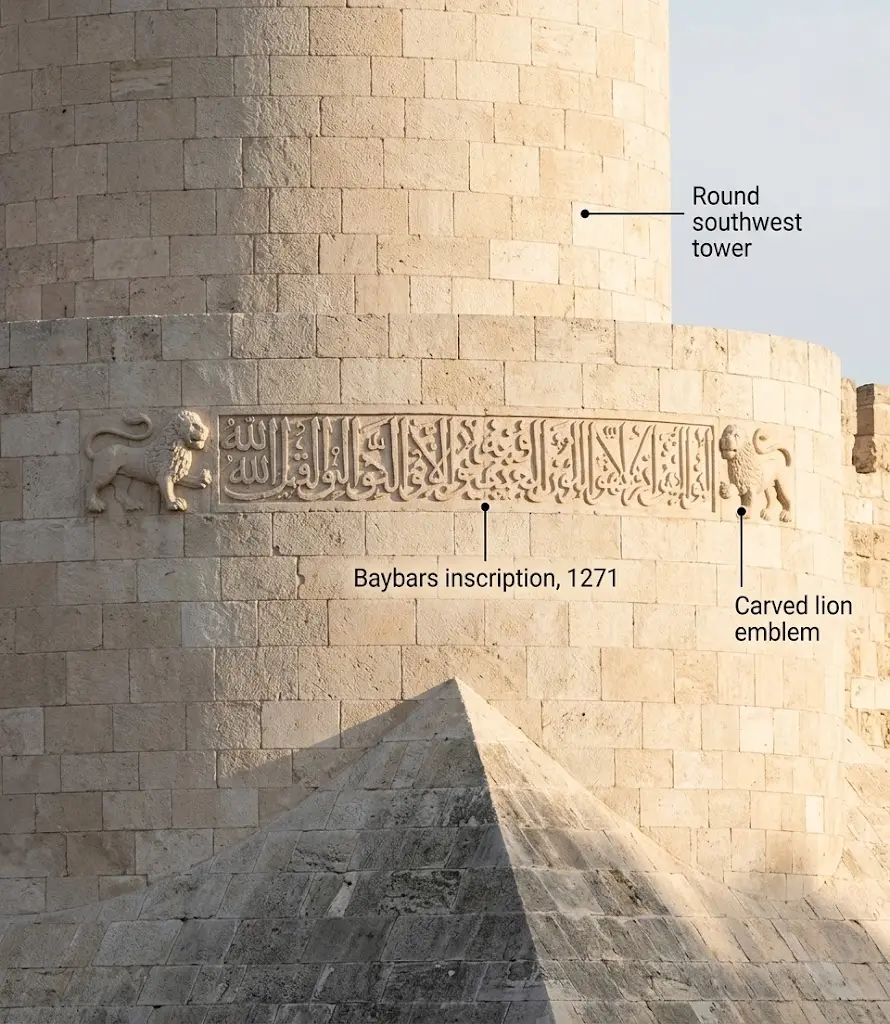
Baybars’s people kept the Hospitaller castle. They needed it. What they built into it is repair and addition, not a new fortress pretending the old one hadn’t worked.
The southwest tower you meet now stands on the stump the Aleppan sappers destroyed. It is round, about fifteen metres across, solid in its lower mass, with a heavy talus. Inside, the chamber is octagonal, groin-vaulted around a central pillar. A long inscription dated 1271 runs on the exterior between two lions, Baybars’s mark. On the pillar itself another text praises al-Malik al-Zahir and his son al-Malik al-Sa’id. Moritz Sobernheim published the Arabic inscriptions of this castle in Matériaux pour un Corpus inscriptionum Arabicarum: Syrie du Nord (Cairo: Institut français d’archéologie orientale, 1909), pages 14–36. Read the stone, then the corpus. Not the other way round.
The southeast gate tower is smaller, about thirteen metres, half-round, with a bent entrance so the portal isn’t presented square to a besieger’s machines. One inscription dates the tower to 1271. Another, over the lintel, dates restoration of the eastern enceinte to 1278. Baybars was dead by then. I nearly wrote that every round tower after the siege is his. It isn’t. A further tower is associated with Sultan Qalawun and the year 1285. A lot of refacing carries no name at all.
The chapel became a mosque. Two mihrabs were cut in. That alteration is easy to miss if you’re hunting “Crusader” details and refusing anything after April.
Under the Ottomans, from 1516, the place stayed a local garrison under a dizdar, the center of a nahiye still called after Ḥiṣn al-Akrād. By the late nineteenth century it was a village stacked into medieval vaults. Families. Animals. Rubbish in the cisterns. That isn’t a decline from a pure monument. It is what happens when a fortress outlives the state that needed it.
How Does the Double Wall at Krak des Chevaliers Actually Work?
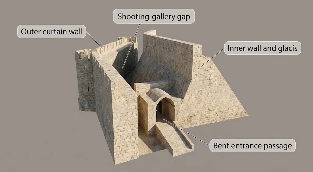
You come in from the east through a bent, vaulted passage on the order of 137 metres — elbows, more than one gate, a portcullis slot, murder-holes in the crown. Call it a corridor and you’ve already misunderstood the wait built into it.
Does that make the castle “concentric,” the way textbooks use the word? No. Concentric, at Beaumaris, means a designed geometrical circuit set inside another. Here the outer enceinte, about nine metres high in the stretches where you can still measure a clean curtain, follows the spur and keeps a tight gap along the west and south. That gap works as a shooting gallery. The inner wall behind it carries the enormous sloping glacis, which stiffens the masonry against mining and against the earthquakes this ridge has always had. Towers project so that arrow slits rake the curtains. Box machicolations cover the foot of the wall in some sectors and not in others. The absence is evidence. Don’t smooth it into a single system drawn on one afternoon.
Inside the upper ward, the hall on the west — rib-vaulted, with tracery that Camille Enlart’s generation wanted to file under French Gothic — sits beside the chapel and a run of vaulted rooms. Enlart’s Les monuments des Croisés dans le royaume de Jérusalem (Paris: Paul Geuthner, 1925–1928) pushed the Western reading hard. The masons were working in local limestone, much of it from the quarry at Magharet al-Dara’a, about two kilometres off the spur, and they were solving Levantine problems: miners, trebuchets, a dry season. Gothic drapery on a window doesn’t cancel that. Jaroslav Folda, Pamela French, and Pierre Coupel published what remained of the chapel painting, including a Presentation in the Temple on the exterior, in Dumbarton Oaks Papers 36 (1982), pages 177–210. Fragments. Red. A little blue. Mostly bare plaster, even then.
Water is the part visitors skip, and it’s the part a siege actually turns on. An aqueduct fed an open reservoir on the east, which doubled as a wet ditch. Vaulted cisterns under the inner court held the rest. The Directorate-General of Antiquities and Museums has treated the inner-court cistern vault as a priority repair. We don’t have a trustworthy head-count of the garrison, and I won’t invent one. Brother-knights were a small professed core. Sergeants and paid men filled out the watch. In 1271 the outer ward also held villagers. Guidebooks still like “two thousand knights.” The latrine chutes cut through the inner parapet were not sized for a small town. They were sized for a garrison. Those aren’t the same problem.
T. E. Lawrence, in the Oxford thesis he submitted in 1910, called this “perhaps the best preserved and most wholly admirable castle in the world.” He was twenty-one. He was working in part from Guillaume Rey’s plates in the Étude sur les monuments de l’architecture militaire des croisés en Syrie (Paris: Imprimerie nationale, 1871), and Rey is off in places. A good sentence. Not a survey.
How Does Krak des Chevaliers Compare with Qal’at Salah El-Din?
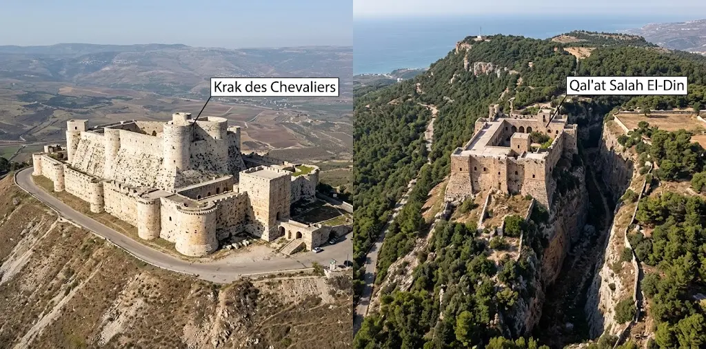
Not as twins. That’s why putting them on one World Heritage form was always an argument, not a geographical claim.
Qal’at Salah El-Din — Saone, as the Franks had it — sits on a ridge nearer Latakia. Its famous ditch is cut down through living rock, a Byzantine and Frankish answer to a different hill. Ayyubid work shows in its upper fabrics. Much of it is ruin. Margat, Qal’at al-Marqab, is the closer relative in institutional terms: another Hospitaller castle, but basaltic, coastal, and held until Qalawun took it in 1285. Krak des Chevaliers watches the gap in pale limestone. Margat watches the sea in black stone. Using one to “illustrate” the other, without that difference, is how slide lectures flatten Syrian castles into a type.
Kennedy’s line that the castle as a fighting machine reached an apogee at Margat and here has a point, and a trap. He meant the integration of curtains, flanking towers, bent entries, and stores. He didn’t mean the two buildings are interchangeable, and on page 9 of the 1994 book the phrase is already doing too much work if you let it. A machine can be copied in a diagram. These weren’t.
| Comparison Aspect | Krak des Chevaliers | Qal’at Salah El-Din |
|---|---|---|
| Location | Spur above al-Hosn, inland, overlooking the Homs Gap | Ridge near Latakia, closer to the coast |
| Building Material | Pale limestone | Mixed Byzantine/Frankish fabric, rock-cut elements |
| Defining Defensive Feature | Double wall with sloping glacis following the spur | Deep ditch cut through living rock |
| Holding Order / Power | Knights Hospitaller (1142–1271), then Mamluks | Byzantine, then Frankish, then Ayyubid |
| Fall Date | 8 April 1271, to Sultan Baybars | 1188, to Saladin |
| Current Preservation | Considered best-preserved Crusader-era castle | Largely ruined in upper fabrics |
| UNESCO Conservation Status (2026) | Corrective measures largely implemented | Master plan and rehabilitation still demanded |
Why Is Krak des Chevaliers Still on UNESCO’s Danger List?
The Committee inscribed “Crac des Chevaliers and Qal’at Salah El-Din” in 2006, decision 30 COM 8B.38, criteria (ii) and (iv). Cultural property. The Krak component is 1229-001, about 2.38 hectares, with a buffer of about 37.69 hectares. The whole property is larger, 8.87 hectares inside a buffer of 167.21 hectares, because it includes the Latakia castle too. Criterion (iv), in the official wording, calls Crac des Chevaliers the best-preserved castle of the Crusader period and an archetype of a military-order castle. Criterion (ii) claims the pair shows a fortification system that “substantially differed from the European rather more passive defence systems” and then travelled back west.
I think criterion (ii), as phrased, still smells of Lawrence’s generation. The exchange was real. The passivity of Europe is a slogan. The outer wall here answers Levantine siege craft as much as it teaches France anything.
Inscription isn’t the Danger List. In 2013, decision 37 COM 7B.57, the Committee put the property on the List of World Heritage in Danger because of destruction and ascertained threats from the war that began in 2011. Shelling in August 2012 damaged the chapel. Further strikes hit the castle through 2013, while fighting went on around al-Hosn. Syrian government forces retook the site in March 2014. The joint World Heritage Centre and ICOMOS mission of October 2025 — Youmna Tabet for the Centre, Jean Yasmine for ICOMOS, on the spur on 20 October — records no further conflict damage at Krak des Chevaliers after that month.
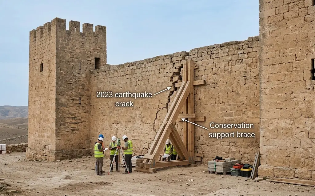
The February 2023 earthquakes are a separate column in the state-of-conservation reports. Don’t fold them into the war. At this castle they brought down part of the wall between the Commander’s Tower and the Knights’ Tower, widened older cracks between towers 101 and 114 at the eastern entrance, cracked the arch of tower 146 and the east wall by the chapel, and took the top of the tower local people call Bint al-Malik. Stones fell at tower 137, north of Baybars’s tower, and at the Commander’s Tower. That is the inventory. It isn’t a metaphor.
Repairs since then are also specific, which is the only way they’re believable. The State Party’s report of 27 January 2026 lists stabilization after the quake on the east wall of building 48 beside the church, on the windows, pier, and wall of building 35 under the Master’s Tower, on central arch B4b in the Hall of Pillars, on the stair pier in the inner court, on wall 19a.1 above the Hall of Knights, and insulation work at tower 4. Earlier, the northern façade of the southern stable, overlooking the ditch, was rebuilt with the Saint Ephrem Patriarchal Development Committee of the Syriac Orthodox Patriarchate of Antioch, alongside DGAM. A lintel in the inner castle and a pier at the knights’ hall were in that same run of work. Two corrective items were still unfinished when the Committee read the file.
I last walked the chapel in 2009. The scraps Folda and his colleagues had published were already faint. I can’t tell you, from the reports alone, which patch of that plaster survived August 2012. That is a failure of the public documentation. It’s also my absence. I won’t pretend a childhood visit and a PDF close the gap.
On the research side, the monument we photograph is partly a Mandate product. Emmanuel Guillaume Rey measured it, imperfectly, in the 1860s and published in 1871. Enlart worked the religious buildings and left the military corpus to Paul Deschamps. Deschamps came in February 1927 with the architect François Anus. His book — Les châteaux des Croisés en Terre-Sainte, I: Le Crac des Chevaliers (Paris: Paul Geuthner, 1934), Bibliothèque archéologique et historique, tome XIX, preface by René Dussaud, text of 327 pages plus an album of 120 plates — is still the survey you argue with, not a book you skip. King called it brilliant. He was right, and he still dissented on the siege.
Here’s the part coffee-table introductions hate. On 16 November 1933 the Antiquities Service moved roughly five hundred people out of the castle. Compensation was set at a million French francs. Pierre Coupel then ran a workforce of about 120 on the clearance and repair. UNESCO’s own authenticity statement says the “relatively recent additions by local villagers were removed” and the medieval structures “liberated of accumulated soil.” Liberated. The villagers of al-Hosn were living in those vaults. The clean medieval section is real, and it was made by eviction. I think that belongs in the Krak des Chevaliers history, not in a footnote about “later accretions.”
Decision 48 COM 7A.17, in 2026, congratulated the State Party for the quality of the work at this castle and said the corrective measures here had largely been met. It then rebuked the state of Qal’at Salah El-Din, demanded a master plan for rehabilitation and use, and demanded a landscape framework for the buffer, where illegal building is still scored on a removal list. It kept the joint property on the List of World Heritage in Danger, and it asked for another report by 1 February 2027.
I’ve read those operative paragraphs twice. They don’t say what the families in al-Hosn, whose houses sit inside the argument about that buffer, mean to do with a slope they already live on. The October 2025 mission could walk the wards. It couldn’t finish that conversation. Neither can I.
| Date | Event | Documented Impact | Category |
|---|---|---|---|
| 2006 | Decision 30 COM 8B.38 | Inscription on the World Heritage List under criteria (ii) and (iv) | Inscription |
| August 2012 | Shelling during the conflict | Damage to the chapel | Conflict damage |
| 2013 | Decision 37 COM 7B.57 | Property placed on the List of World Heritage in Danger | Danger listing |
| March 2014 | Site retaken by Syrian government forces | End of active fighting around al-Hosn | Stabilization |
| February 2023 | Regional earthquakes | Wall collapse between Commander’s and Knights’ Towers; cracks at Towers 101, 114, 146; top of Bint al-Malik Tower lost | Earthquake damage |
| October 2025 | Joint World Heritage Centre / ICOMOS mission | No further conflict damage recorded at Krak des Chevaliers since 2014 | Monitoring |
| 27 January 2026 | DGAM state-of-conservation report | Stabilization of Building 48, Building 35, Arch B4b, Wall 19a.1, and Tower 4 | Repair work |
| 2026 | Decision 48 COM 7A.17 | Krak measures largely implemented; property remains on the Danger List due to Qal’at Salah El-Din and buffer zone issues | Still endangered |
This article draws on the latest official reports and academic studies on Krak des Chevaliers:
- UNESCO World Heritage Centre (2006–2026): Inscription file No. 1229, Danger List decisions (37 COM 7B.57, 48 COM 7A.17), and state-of-conservation reports including the October 2025 joint mission.
- Directorate-General of Antiquities and Museums of Syria (DGAM): Field reports and the 27 January 2026 post-earthquake stabilization report.
- Hugh Kennedy, Crusader Castles (Cambridge University Press, 1994): Reconstruction of the 1271 siege sequence.
- D. J. Cathcart King, “The Taking of Le Krak des Chevaliers in 1271,” Antiquity 23 (1949): Foundational critical reading of the Arabic siege narratives.
- Jean Mesqui and Maxime Goepp, Le Crac des Chevaliers (Académie des Inscriptions et Belles-Lettres, 2018): Current architectural and historical synthesis.
- French Ministry of Culture, Krak des Chevaliers heritage portal: Siege chronology and Mamluk-era architectural modifications.
References
Encyclopedia of Syria assumes no responsibility for any use of this content that deviates from its educational and documentary purpose.
Dr. Abdul Rahman Al-Shahbandar — History Professor & Researcher